Randonnée Marche La Bretonnière-la-Claye - La Claye - Photo
 sr230578
sr230578

Utilisateur

© OpenStreetMap contributors
Longueur
Longueur
8,1 km
Altitude max
Altitude max
18 m
Dénivelé positif
Dénivelé positif
50 m
Km-Effort
Km-Effort  
8,8 km
Altitude min
Altitude min
0 m
Dénivelé négatif
Dénivelé négatif
50 m
Boucle
Boucle
Oui
Date de création :
2014-12-10 00:00:00.0
Dernière modification :
2014-12-10 00:00:00.0

(0 Avis)

Marche
Marche
2h21
Difficulté : Facile

Scannez ce code QR pour ouvrir la randonnée dans l'application SityTrail

Application GPS de randonnée GRATUITE

Logo SityTrail SityTrail

IGN / Instituts géographiques

Télécharger SityTrail sur l'App Store Télécharger SityTrail sur Google Play

Logo SityTrail SityTrail World

Le monde est à vous

Télécharger SityTrail sur l'App Store Télécharger SityTrail sur Google Play Télécharger SityTrail sur Huawei AppGallery

À propos

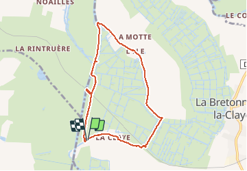
Randonnée Marche de 8,1 km à découvrir à Pays de la Loire, Vendée, La Bretonnière-la-Claye. Cette randonnée est proposée par sr230578.

Description

circuit pédestre

Profil altimétrique

Points d'intérêt

Point d'intérêt La Bretonnière-la-Claye - Point 1 - Photo
sr230578
LA BRETONNIÈRE-LA-CLAYE 

Localisation

Pays :
France
Région :
Pays de la Loire
Département/Province :
Vendée
Commune :
La Bretonnière-la-Claye
Localité :
Unknown
Départ:(Dec)
Départ:(UTM)
631158 ; 5148621 (30T) N.

Randonnées à proximité

Randonnée Marche Le Champ-Saint-Père - (Compostelle) du Champ Saint Père à Triaize - Photo
Marche
webmammuth

Marche

Moyen
(1)
Le Champ-Saint-Père, Pays de la Loire, Vendée, France
28 km | 31 km-effort
6h 42min
Non
Randonnée Marche La Bretonnière-la-Claye - Mortevielle  - Photo
Marche
hoquet

Marche

La Bretonnière-la-Claye, Pays de la Loire, Vendée, France
7,6 km | 8,2 km-effort
1h 39min
Oui
Randonnée Marche Le Champ-Saint-Père - 12 km. Écoles Champ Saint Père.  - Photo
Marche
hoquet

Marche

Moyen
Le Champ-Saint-Père, Pays de la Loire, Vendée, France
13,1 km | 15,3 km-effort
3h 52min
Non
Randonnée A pied Saint-Cyr-en-Talmondais - st-cyr-en-talmondais/st benoist - Photo
A pied
cath310

A pied

Facile
Saint-Cyr-en-Talmondais, Pays de la Loire, Vendée, France
17,6 km | 19,2 km-effort
4h 21min
Oui
Randonnée A pied Le Champ-Saint-Père - la pierre des fées CHAMP SAINT PERE 85 - Photo
A pied
cath310

A pied

Facile
Le Champ-Saint-Père, Pays de la Loire, Vendée, France
13,4 km | 15,7 km-effort
3h 33min
Oui
Randonnée A pied La Bretonnière-la-Claye - S10-La Claye 8,5 - Photo
A pied
gegedo

A pied

Facile
La Bretonnière-la-Claye, Pays de la Loire, Vendée, France
8,8 km | 9,7 km-effort
2h 12min
Oui
Randonnée Marche Le Champ-Saint-Père - Champ St père - Photo
Marche
hoquet

Marche

Le Champ-Saint-Père, Pays de la Loire, Vendée, France
11,4 km | 12,8 km-effort
4h 9min
Non
Randonnée Marche Le Champ-Saint-Père - La pierre aux fées - Photo
Marche
neoroll44

Marche

Facile
Le Champ-Saint-Père, Pays de la Loire, Vendée, France
13,4 km | 15,8 km-effort
3h 40min
Oui
Randonnée Marche La Bretonnière-la-Claye - Boucle del'ile de la Bretonnière- La Claye - Photo
Marche
tupeutla

Marche

Facile
La Bretonnière-la-Claye, Pays de la Loire, Vendée, France
13,1 km | 14,3 km-effort
3h 11min
Oui


Fermer
Mes abonnements